
COURSE

JUMP TO COURSE
Mobile phone users, please rotate to landscape view or view on a computer screen for the best viewing experience.
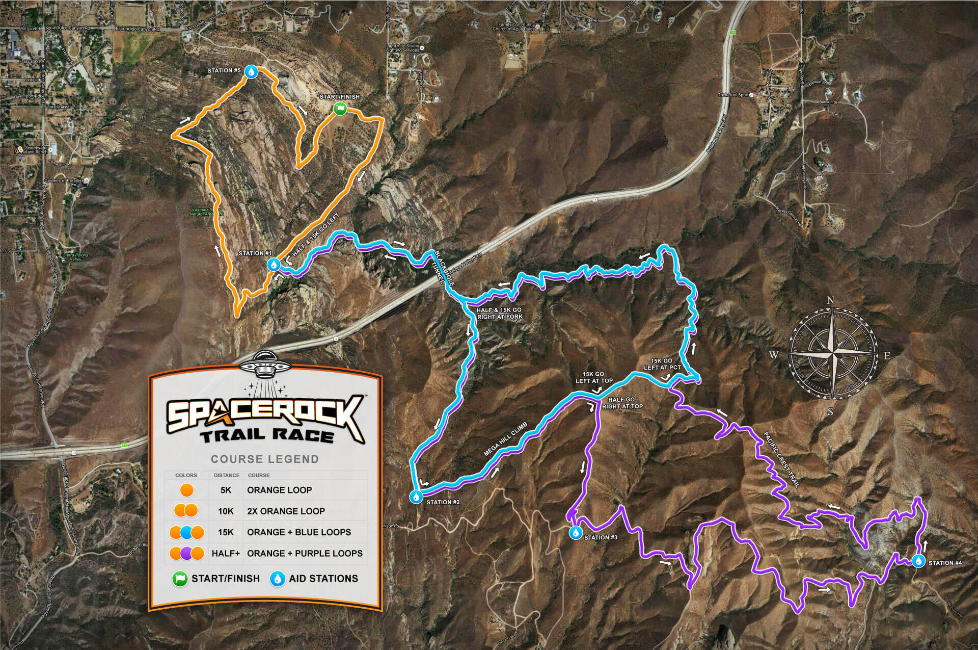
Grab or tap the slider to view the standard terrain map or satellite map below.
Note: Fly thorough video is from the original 5K loop before 2023 changes.
Grab or tap the slider to view the standard terrain map or satellite map below.
Download a large-size terrain map or satellite map.
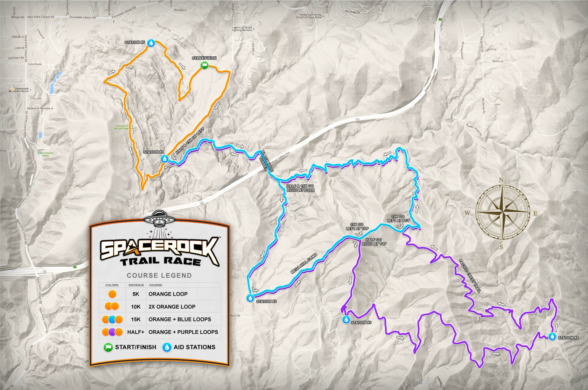
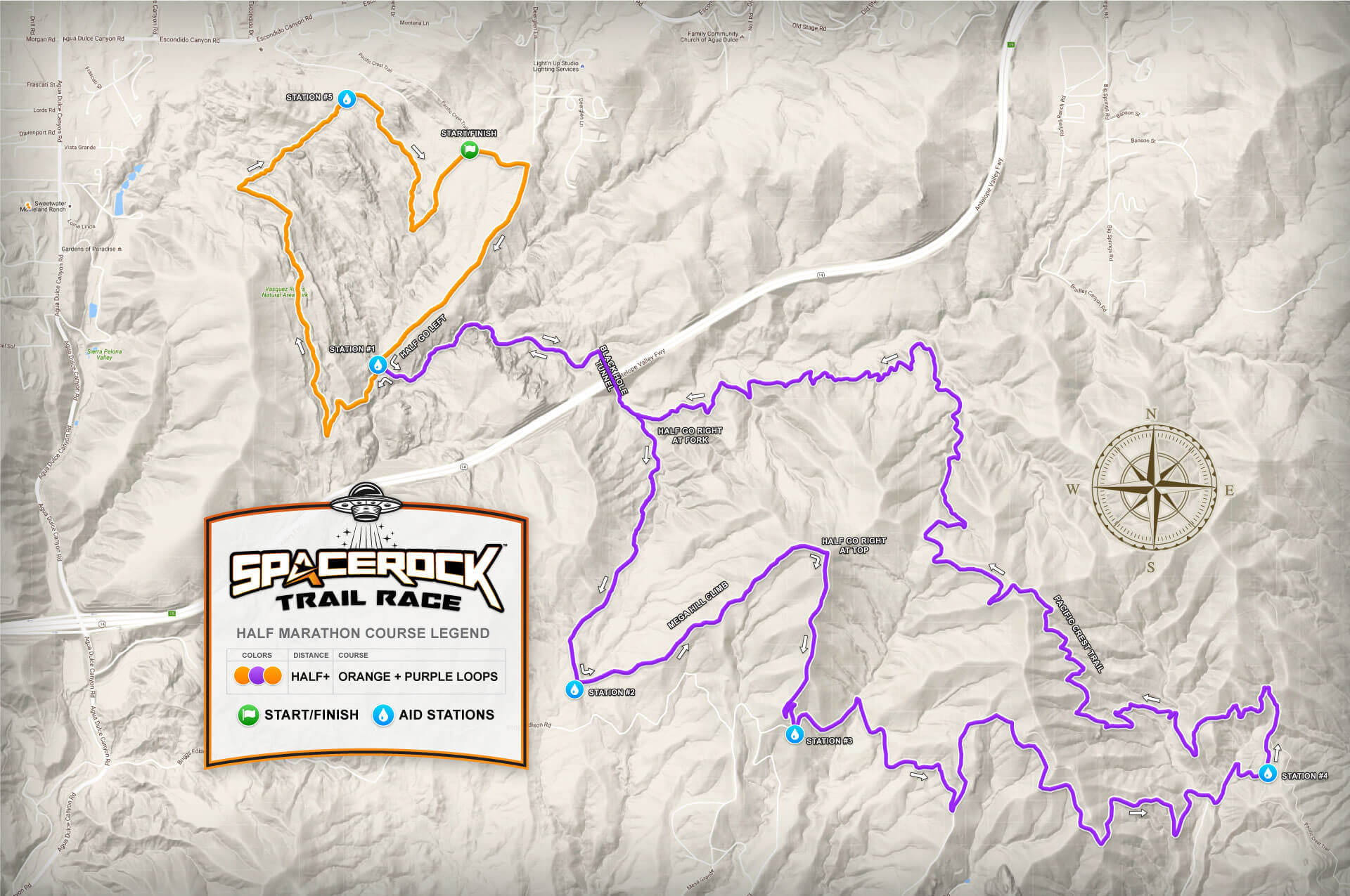
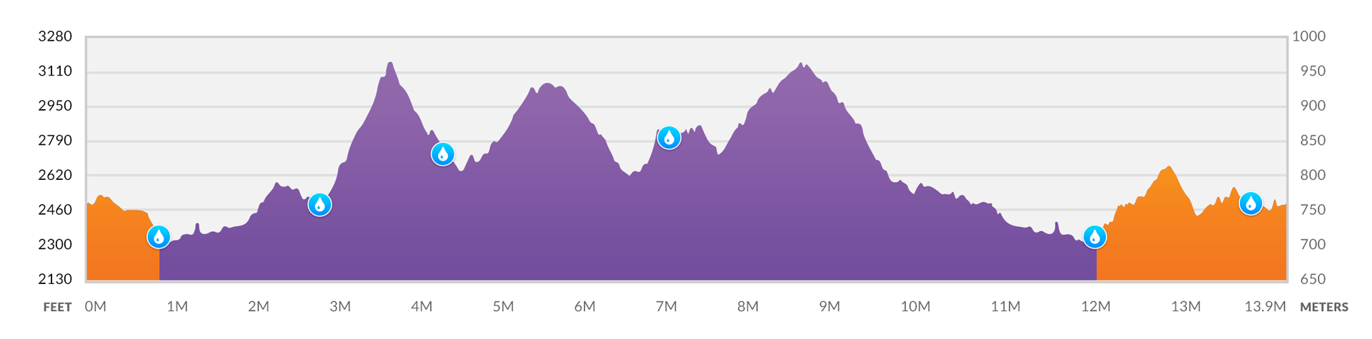
The Half Marathon is an advanced course and provides the most challenge for runners, the purple loop features several challenging elevation climbs and descents. Runners should prepare in the weeks leading up to the race with elevation training to ensure they are ready for a spectacular race.
The Half Marathon trail course consists of two separate loops, the orange loop, and the purple loop, these two combined create a slightly longer Half Marathon course at approximately 13.9 miles (22.3K) distance.
Going from the start Half Marathon runners will follow the orange course to the first aid station. From this point, half runners will take the LEFT fork to begin the purple course into the canyon section, then into the "black hole" tunnel. After coming out of the tunnel half runners go RIGHT at the fork and follow the course trail markings guiding runners onto the challenging mountain section climbing three large peaks and passing three additional aid stations before returning to the PCT trail that heads back to the tunnel and returning to the first aid station to complete the purple course.
Note: At station #4, Half Marathon runners are required to pick up a special race item and bring it back to the finish line as proof of completing the course.
After completing the purple loop and returning to the first aid station, half marathon runners now go LEFT to continue to the orange course going around Vasquez Rocks park to the next aid station and into the finish line to complete the orange loop.
The course will be marked with flagging throughout and signs at key locations, the flagging color will match the course colors from the map. Half marathon runners need to follow the orange and purple flagging.

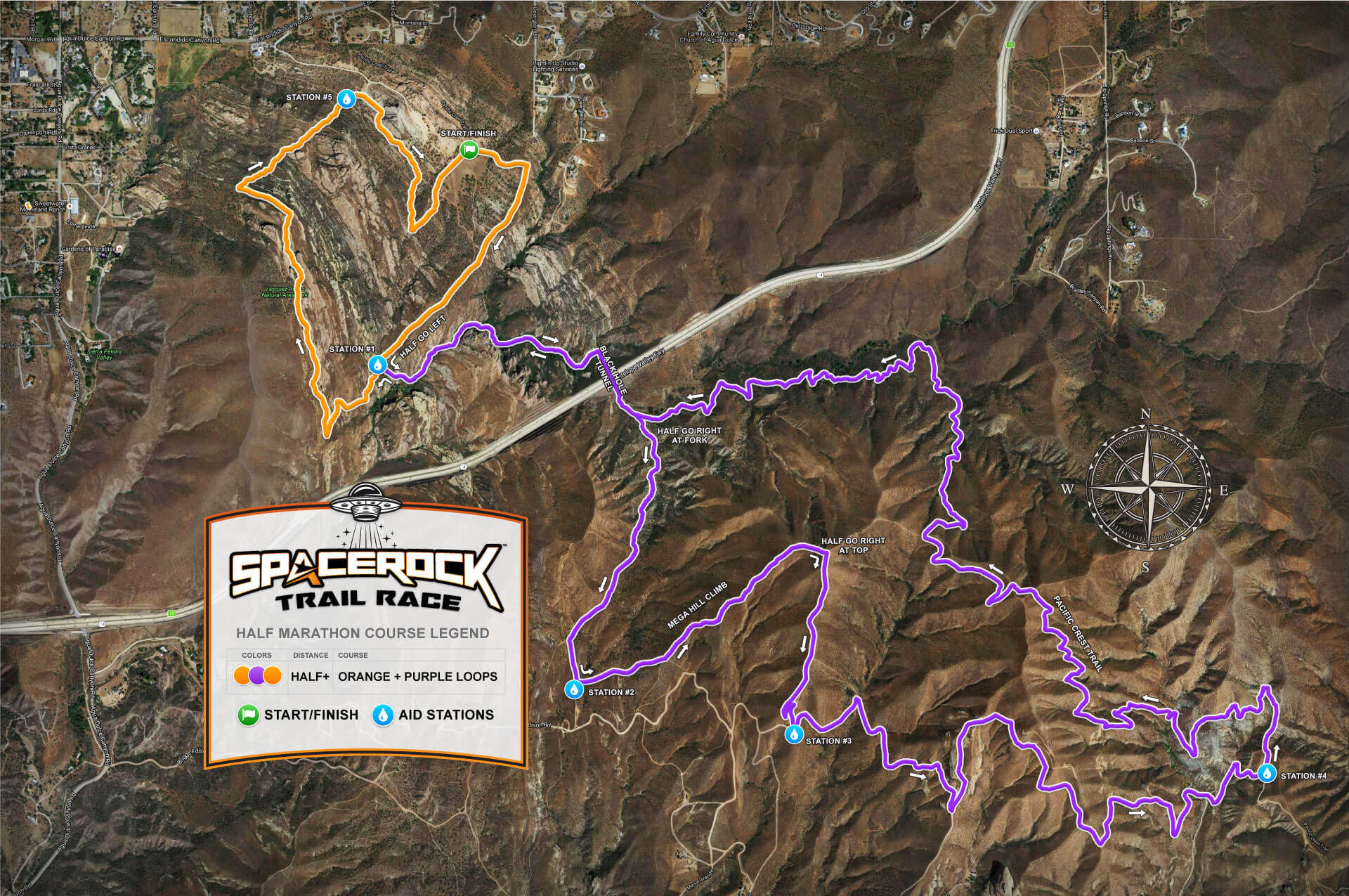
Mobile phone users, please rotate to landscape view or view on a computer screen for the best viewing experience.
Half Marathon+ runners will visit a total of 6 aid stations throughout the course. Below shows the sequence and approximate mile mark for each station for the Half Marathon course.
IMPORTANT: The back half of the purple loop from Station #4 to #1 is the longest distance between stations, approximately 5-miles on the PCT trails with a large climb. Please make sure you stop and properly fuel up at Station #4 before proceeding. Half Marathon runners are required to carry at least one runner's water bottle or hydration pack.
| SEQUENCE | STATION | MILE* | GAP* | NOTES |
|---|---|---|---|---|
| 1. | Start | 0 | 0.8 | Start orange course |
| 2. | Station #1 | 0.8 | 1.8 | Fork: go left to start the purple course |
| 3. | Station #2 | 2.6 | 1.5 | Purple course, start of the mega hill |
| 4. | Station #3 | 4.1 | 2.6 | Purple course, start dirt road section |
| 5. | Station #4 | 6.7 | 4.9 | Purple course, end dirt road section, long distance to #1 |
| 6. | Station #1 | 11.6 | 1.7 | Second time at the station. Fork: go left to finish the orange course |
| 7. | Station #5 | 13.3 | 0.6 | Final station |
| 8. | Finish | 13.9 | Finish line |
*Approximate mile mark distances.
Stations will contain water, electrolytes, GU gels and chomps, salt capsules, and other essential items such as a first aid kit, ice packs, and toilet paper. We highly recommend that you plan to run with a runner's bottle or hydration pack, you can refill them at each station with water and electrolytes.
IMPORTANT: The Half Marathon+ course is very challenging, it is more like ultra trail conditions, with approximately 3000 feet of elevation climbing and descent over three large peaks. It is recommended that runners are conditioned and trained for elevation gains and similar distances on trails to ensure a great trail race experience.
Station #1 (0.8M)
Station #2 (2.6M)
Station #3 (4.1M)
Station #4 (6.7M)
Station #1 (11.6M)
Station #5 (13.3M)
A copy of the Half Marathon course map is available for viewing on Google Maps, Hello Drifter, and also for download as GPS track in the standard GPX or KML formats below. To Save GPX/KML files, right-click and choose Save Link As...
Grab or tap the slider to view the standard terrain map or satellite map below.
Download a large-size terrain map or satellite map.
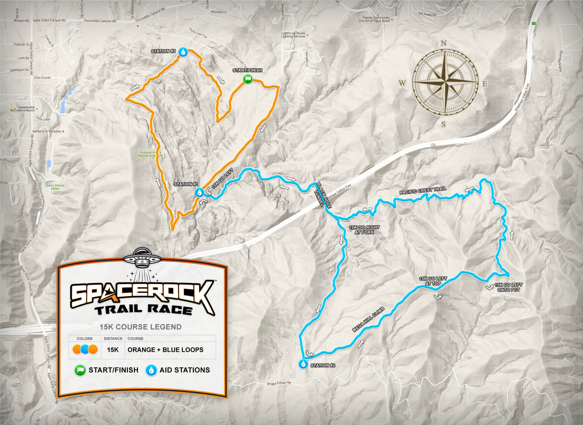
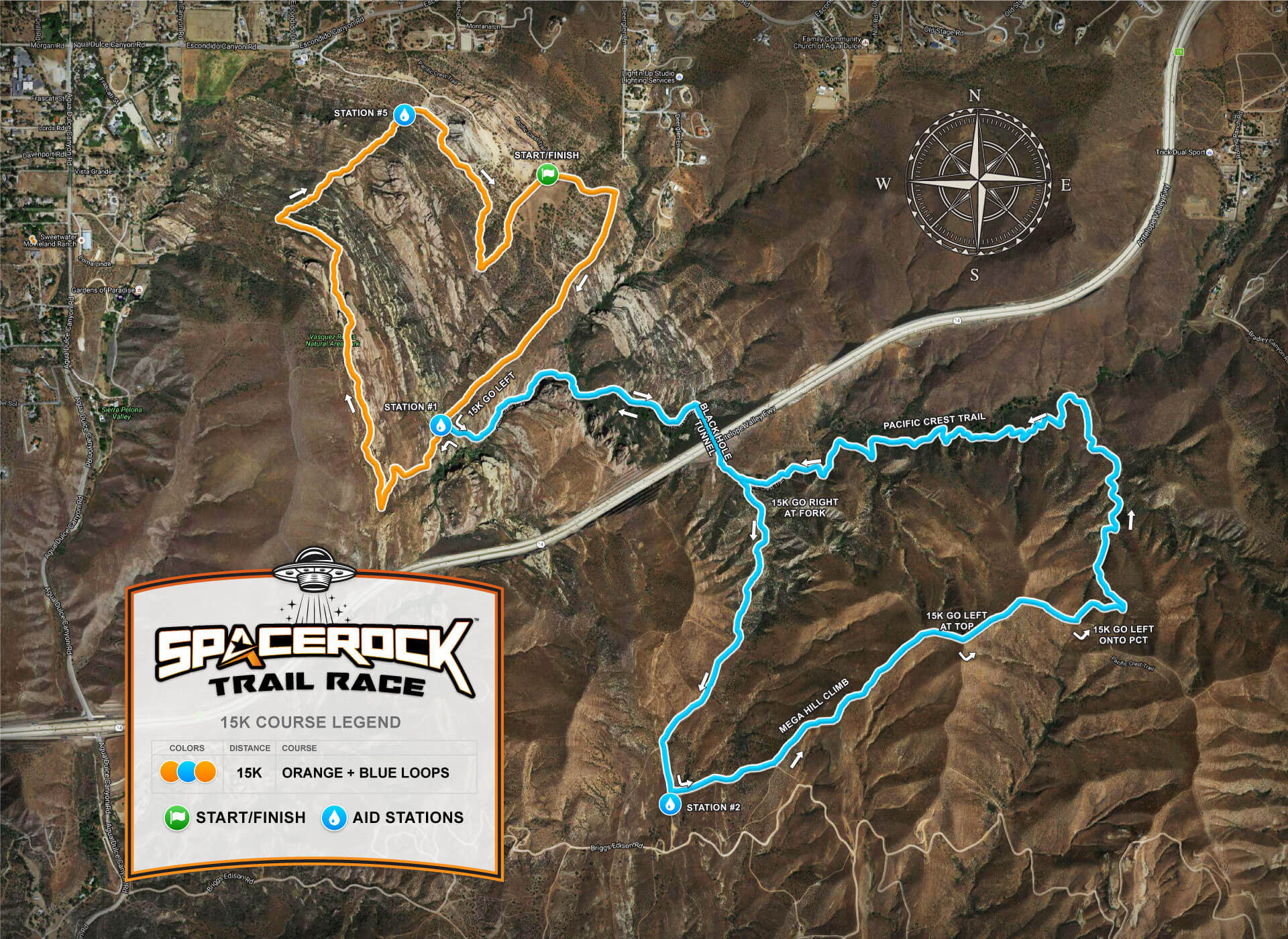
The 15K is an intermediate to an advanced course that is designed for those looking for a challenge, but not ready for the Half Marathon+ distance. This course provides good challenges for runners, the blue loop features the mega hill climb with the biggest elevation gain and descent. Runners should prepare in the weeks leading up to the race with elevation training to ensure they are ready for a spectacular race.
The 15K trail course consists of two separate loops, the orange loop, and the blue loop, these two combined create a 14.25K course distance.
Going from the start 15K runners will follow the orange course to the first aid station. From this point, 15K runners will take the LEFT fork to begin the blue course into the canyon section, then into the "black hole" tunnel. After coming out of the tunnel half runners go RIGHT at the fork and follow the course trail markings guiding runners to aid station #2 and beginning the mega hill climbing section. When reaching the top of the mega hill 15K runners will go LEFT to descend, at the bottom turn LEFT onto the PCT trail that heads back to the tunnel and returns to the first aid station to complete the blue course.
Note: At station #2, 15K runners are required to pick up a special race item and bring it back to the finish line as proof of completing the course.
After completing the blue loop and returning to the first aid station, 15K runners now go LEFT to continue to the orange course going around Vasquez Rocks park to the next aid station and into the finish line to complete the orange loop.
The course will be marked with flags throughout and signs at key locations, the flagging color will match the course colors from the map. 15K runners need to follow the orange and blue flagging.

Mobile phone users, please rotate to landscape view or view on a computer screen for the best viewing experience.
15K runners will visit a total of 4 aid stations throughout the course. Below shows the sequence and approximate mile mark for each station for the 15K course.
IMPORTANT: The back half of the blue loop from Station #2 back to #1 is the longest distance between stations, approximately 4-miles including the mega hill climbing and PCT trails. Please make sure you stop and properly fuel up at Station #2 before proceeding. 15K runners are required to carry at least one runner's water bottle or hydration pack.
| SEQUENCE | STATION | MILE* | GAP* | NOTES |
|---|---|---|---|---|
| 1. | Start | 0 | 0.8 | Start orange course |
| 2. | Station #1 | 0.8 | 1.8 | Fork: go left to start the blue course |
| 3. | Station #2 | 2.6 | 4 | Purple course, start of the mega hill |
| 4. | Station #1 | 6.6 | 1.7 | Second time at the station. Fork: go left to finish the orange course |
| 5. | Station #5 | 8.3 | 0.6 | Final station |
| 6. | Finish | 8.9 | Finish line |
*Approximate mile mark distances.
Stations will contain water, electrolytes, GU gels and chomps, salt capsules, and other essential items such as a first aid kit, ice packs, and toilet paper. We highly recommend that you plan to run with a runner's bottle or hydration pack, you can refill them at each station with water and electrolytes.
IMPORTANT: The 15K course can be challenging with 1,800 feet of elevation climbing and descent over three large peaks. It is recommended that runners are conditioned and trained for elevation gains and similar distances on trails to ensure a great trail race experience.
Station #1 (0.8M)
Station #2 (2.6M)
Station #1 (6.6M)
Station #5 (8.3M)
A copy of the 15K course map is available for viewing on Google Maps, Hello Drifter, and also for download as GPS track in the standard GPX or KML formats below. To Save GPX/KML files, right-click and choose Save Link As...
Note: Fly thorough video is from the original 5K loop before 2023 changes.
Grab or tap the slider to view the standard terrain map or satellite map below.
Download a large-size terrain map or satellite map.
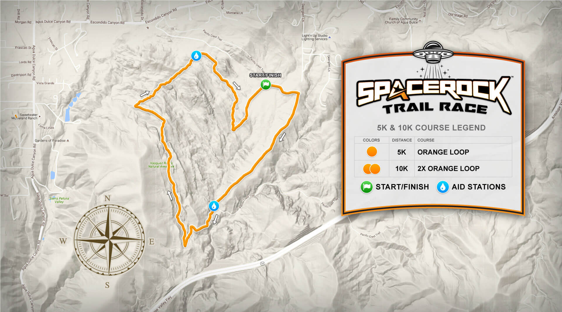
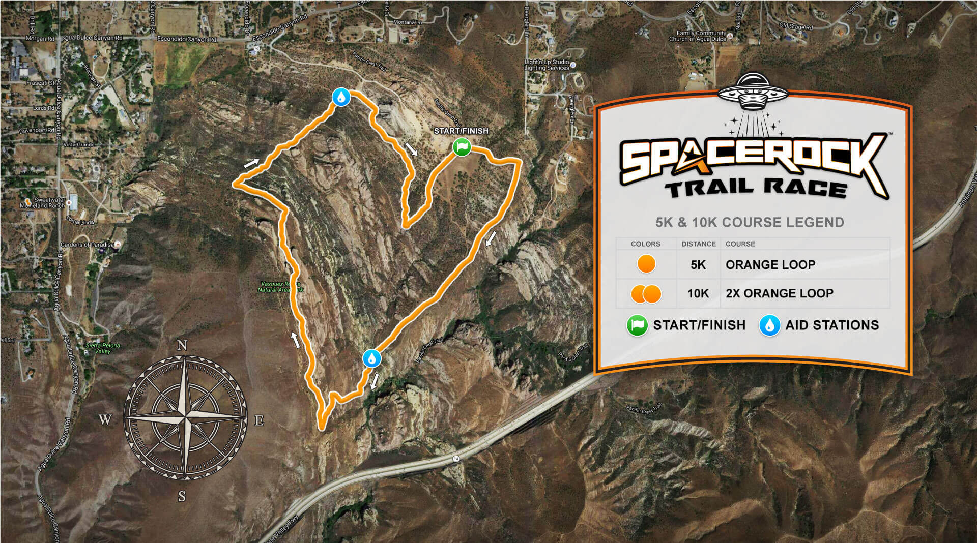
The 5K / 10K course is great for first-time trail runners, hikers, or walkers looking to experience the beauty of Vasquez Rocks. It will provide light to moderate challenges for participants.
The 5K trail course consists of one loop, the orange loop, which makes the 5K distance. 10K runners will complete 2 loops.
Going from the start 5K / 10K runners will follow the orange course to the first aid station. From this point, 5K / 10K will take the RIGHT fork going around Vasquez Rocks park to the next aid station and into the finish line to complete the orange loop.
10K runners will pass through the start/finish line and begin their second lap. When they return the second time they will be finished.
The course will be marked with flagging throughout and signs at key locations, the flagging color will match the course colors from the map. 5K / 10K runners need to follow orange flagging.

Mobile phone users, please rotate to landscape view or view on a computer screen for the best viewing experience.
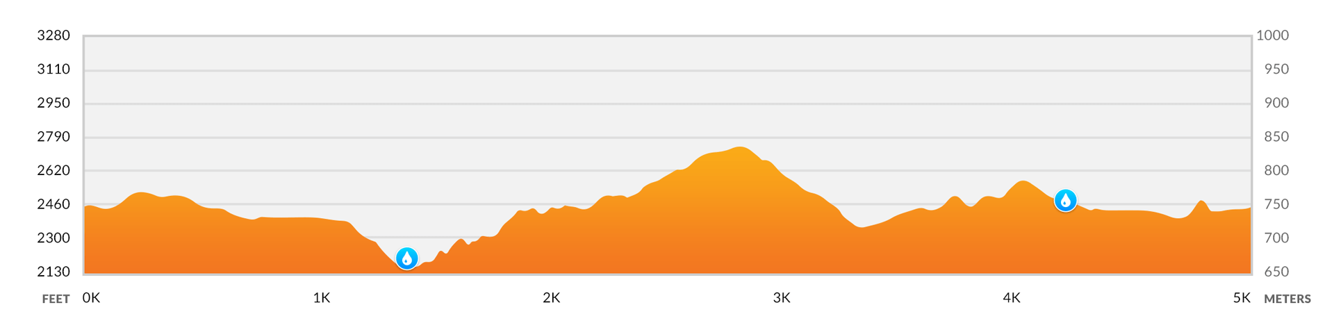
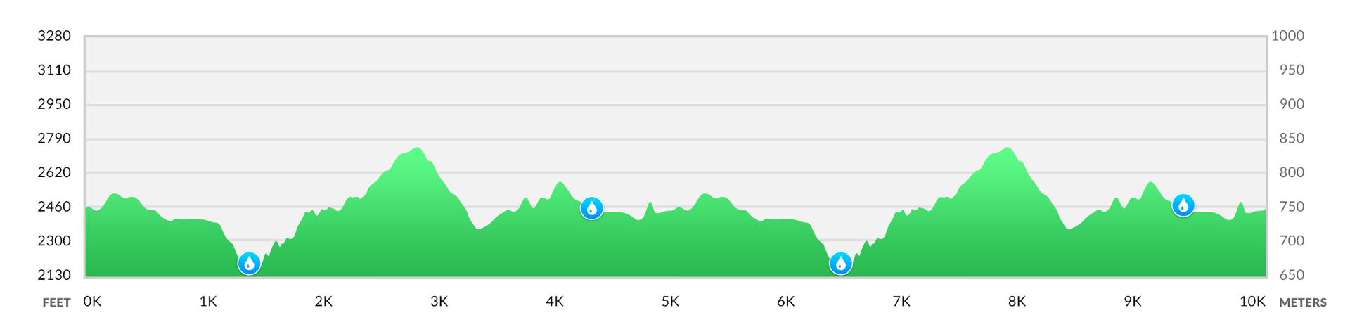
5K loop has 2 aid stations throughout the course, 10K runners will hit each twice for a total of 4 stations. Below shows the sequence and approximate mile/kilometer mark for each station for the 5K course.
5K STATION SEQUENCE
| SEQUENCE | STATION | MILE* | GAP* | NOTES |
|---|---|---|---|---|
| 1. | Start | 0 | 0.8 | Start orange course |
| 2. | Station #1 | 0.8 | 1.7 | Fork: go right following orange course |
| 3. | Station #5 | 2.5 | 0.6 | Final station |
| 4. | Finish | 3.1 | Finish line |
10K STATION SEQUENCE
| SEQUENCE | STATION | MILE* | GAP* | NOTES |
|---|---|---|---|---|
| 1. | Start | 0 | 0.8 | Start orange course |
| 2. | Station #1 | 0.8 | 1.7 | Fork: go right following orange course |
| 3. | Station #5 | 2.5 | 0.6 | Second station |
| 4. | Lap #1 Finish | 3.1 | 0.8 | Complete first lap |
| 5. | Station #1 | 3.9 | 1.7 | Second time at station, fork: go right following the orange course |
| 6. | Station #5 | 5.6 | 0.6 | Second time at station, final station |
| 7. | Finish | 6.2 | Finish line |
*Approximate mile mark distances.
Stations will contain water, electrolytes, GU gels and chomps, salt capsules, and other essential items such as a first aid kit, ice packs, and toilet paper. We highly recommend that you plan to run with a runner's bottle or hydration pack, you can refill them at each station with water and electrolytes.
Station #1 (0.8M)
Station #5 (2.5M)
Station #1 (0.8M)
Station #5 (2.5M)
Station #1 (3.9M)
Station #5 (5.6M)
A copy of the 5K / 10K course map is available for viewing on Google Maps, Hello Drifter, and also for download as GPS track in the standard GPX or KML formats below. To Save GPX/KML files, right-click and choose Save Link As...
Disclaimer: Please note that race information here represents what is planned for the SPACEROCK Trail Race. Locations, course variations, and changes may apply depending on conditions, availability, and improvements. We strive to make the best experience for the runners. Thank you for understanding.


Sponsors
We are currently accepting sponsors for the 2024 race, grow your business as a sponsor at the 8th annual SPACEROCK Trail Race!


Thank you to our 2023 sponsors for helping to create a spectacular race experience!


